Urangan South Local Area Plan
-
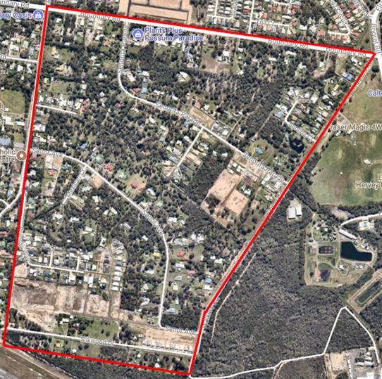
The extent of the Urangan South locality is bound by Boundary Road to the north, Hughes Road to the west, the property boundaries adjoining the Hervey Bay airport to the south and Walkers Road to the east.
The total area of the defined Urangan South locality is 137.3 hectares including internal roads and drainage corridors. There is a mix of sewered and unsewered lots, ranging in size from approximately 800m2 to 3.6 hectares.
-
Zoning under the Hervey Bay Planning Scheme 2006
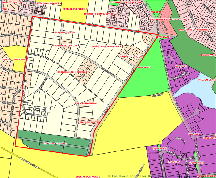
Previously, under the Hervey Bay Planning Scheme 2006 the zoning within the locality generally restricted any further subdivision of lots.
- The majority of the locality formed part of the Emerging Community Zone;
- The balance of lots being located in either Park Residential Zone or Rural Residential Zone; and
- A single lot in the Special Purposes 2 (Government Purposes) Zone as shown on the superseded zone map below.
The minimum lot sizes for new lots were:
- Emerging Communities – 50ha
- Park Residential – 2000m2
- Rural Residential – 2ha
Current zoning under the Fraser Coast Planning Scheme 2014
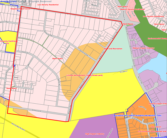
Under the Fraser Coast Planning Scheme 2014:
- The majority of the locality is within the Low Density Residential Zone which generally allows for smaller lots (between 500m2 if sewered and 2000m2 if not sewered). Approximately 250 lots have been approved in the area to date since 2014.
- There are a number of lots that are zoned Limited Development (Constrained Land) Zone which restricts most development due to either the Public Safety Area of the Hervey Bay Airport or the Pugul Waste Water Treatment Plant Odour Buffer.
- There is a couple of very narrow drainage corridors located within the locality that are located within the Open Space Zone. There is one lot in the Community Facilities Zone (CF2).
-
An external consultant has been engaged to assist Council with the development of the Local Area Plan.
Once the plan is endorsed by Council, amendments to the Fraser Coast Scheme 2014 will be undertaken with a timeframe of 6-18 months. Please note that until amendments to the planning scheme are adopted, the current planning scheme provisions will continue to apply.
STAGE SUMMARY OF KEY TASKS ESTIMATED TIMEFRAMES Stage 1 - Commencement and scoping - Project commencement
- Confirmation of project approach and method
End June 2018 Stage 2 - Development Area Context Analysis
- Undertake a technical review of planning and engineering matters
- Community engagement forum No.1
- Compile outputs of analysis and information review.
Outputs: Context Analysis and Options Review (PDF)
End October 2018 Stage 3 - Draft structure plan design and structure plan report preparation - Prepare draft land use structure plan
- Prepare draft water and sewerage report
Note - The structure plan is a large document which provides the required background information for the project. This informs the Local Area Plan in Stage 6 which condenses the background information into clear policies that can be used by the community.
November 2018 - July 2019 Stage 4 - Consultation -
Release of draft land use structure plan
Outputs: Draft Urangan South Land Use Strategy and Local Area Plan - draft Structure Plan Report
- Landowner meetings with Council Officers
- Consideration of public submissions
July 2019 - 19 August 2019 Stage 5 - Final Structure Plan
- Incorporate community feedback into structure plan.
- Finalise land use structure plan and lot layout
- Finalise infrastructure requirements and calculations
Commenced with Council resolution 23 October 2019 Stage 6 - Local Area Plan - Preparation of Local Area Plan
Commenced with Council resolution 23 October 2019 -
A Local Area Plan is a planning document which identifies the preferred types of development for an area and where they should be located. It is developed from a structure plan which is a large document that provides background information on the area. The Local Area Plan condenses the background information into clear policies that can be used by the community.
Local Area Plans are developed to provide focused planning guidance for local areas to achieve the following:
- a shared vision for the local area;
- address key local planning issues;
- establishment of an integrated approach to local planning; and
- a sensible management of future development outcomes.
-
Details of community engagement activities are provided in the table below.
Type of engagement
Date/Time/Location Stage 2 - Survey
A survey was open to the public between 10-24 August 2018
Summary of survey results (PDF)Stage 2 - Community engagement forum No.1
- a brief overview of the project
- summary of site constraints
- summary of key opportunities
- summary of alternative flooding/drainage scenarios
- community questions and comments
A community engagement forum was held on the 19 September 2018. Over 45 people attended the forum providing valuable feedback and comments to Council.
Stage 4 - Consultation
- Owners of properties in the Urangan South area are invited to meet with Council officers to discuss the proposed structure plan in the context of their specific property
- Community to provide feedback through written submissions
Public consultation was undertaken between 24 July 2019 and 19 August 2019.
Planning scheme amendments
Once the local area plan is drafted and endorsed by Council, amendments to the Fraser Coast Scheme 2014 will be required. Public consultation, including opportunity to make submissions, will be undertaken in accordance with the Planning Act 2016.To be advised. Amendment process can take 6-18 months to complete.