Burrum/Cherwell Area
Local Information
-
Evacuation Information
The primary role of the Local Disaster Management Group (LDMG) with regards to the management of evacuees is to provide safe, temporary accommodation for a short period until a threat has passed.
The first preference is for people to ‘shelter-in-place’ – stay where you are – while this is the preferred option, it may not be possible due to the type of disaster occurring (i.e. approaching bushfire). If you are required to evacuate, the second preference is for people to leave the impacted area and shelter with friends and family (if safe to do so).
Should there be a need to open an evacuation centre in Howard, the Local Disaster Management Group will ensure that there is ample notice provided.
Information relating to the opening of Evacuation Centres will be announced via our information sources – please tune in to local radio ABC Wide Bay FM 100.1 or live stream ABC Listen - Wide Bay and follow updates on Facebook and Council’s Website and the Fraser Coast Disaster Dashboard.
Storm Tide Evacuation Zones
The following maps are indicative of possible evacuation zones for storm surge inundation.
Pacific Haven Flooding
Residents in Pacific Haven may be isolated due to flooding in the Burrum River and Cherwell River. Whether it is riverine flooding or severe weather, access may be cut some hours before floodwaters begin to enter properties. It is important to monitor flood levels, flood cameras and information from reliable sources such as the Bureau of Meteorology. This information will assist you in making the decision whether to stay or to evacuate before your evacuation route becomes impassable.
Please monitor the following links and sign up to the Fraser Coast Disaster Dashboard to receive notifications during natural disaster events.
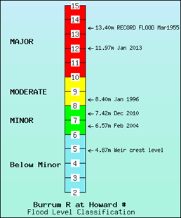
Latest River Heights for the Cherwell-Burrum, Burnett, Kolan Rivers and tributaries
Latest River Heights for the Burrum River at Howard
Latest River Heights for Cherwell River at Pacific Haven
Queensland Rainfall and River Conditions
Flood Cameras have been placed along Pacific Haven Drive. These can be viewed on the Flood Camera layer on the Fraser Coast Disaster Dashboard.
Mapping
Flood Level Predictions Pacific Haven
The estimated maximum water level surfaces for the Burrum River catchment have been estimated based on the flood model calibrated against the February 2008, December 2010 and January 2013 flood events.
-
Lake Lenthall is a great recreational facility for those who enjoy camping, boating, fishing, kayaking or just relaxing in a family-friendly environment. It is commonly referred to as Lenthalls Dam and is located off the Bruce Highway between Maryborough and Torbanlea in the Wongi Forestry.
Visitors need to be aware that access to Lake Lenthall is via a rough dirt road. The road is controlled and maintained by Forest Products, a business unit of the Queensland Government. Accessing Lake Lenthall is at your own risk and a 4WD is recommended. The Lake Lenthall Ranger will not be able to assist with towing vehicles if they become stuck.Emergency Information
Flows from Lenthalls Dam follow the Burrum River to the coastal river mouth at Burrum Heads. Increased flows from Lenthalls Dam will result in increased river levels and could cause flooding that may affect downstream townships adjacent to Burrum River, including Burrum Town, Howard, Burrum River, Pacific Haven, Buxton, and Burrum Heads. Flooding downstream of Lenthalls Dam may also impact the Bruce Highway in the vicinity of Howard, where it crosses over the Burrum River.
The Emergency Action Plan (EAP) for Lenthalls Dam covers five emergency key events (flooding, piping, earthquake, high energy impact, and terror attack) within Council's Dam Safety Management Program.
Lake Lenthall Ranger's Office can be contacted on (07) 4129 4833.
-
The Local Disaster Management Group has recognised the need to remain in contact with the communities that may become isolated, before, during and after disaster events, to keep them informed and to understand their needs.
The Community Resilience Network has been established in locations throughout the Fraser Coast local government area. These committees have specific roles in assisting the Fraser Coast Local Disaster Management Group in the following matters:
- Helping to build community resilience by spreading the disaster awareness message so people are prepared
- Being the eyes and ears on the ground and sending information back to the Local Disaster Coordination Centre during an event
- Being involved in the community’s recovery process.
The towns of Pacific Haven and Howard have active Community Resilience Networks.
PHEAG (Pacific Haven Emergency Action Group) is a community organisation which aims to maintain awareness of and resilience to disasters.
The Howard CRN are members of the Howard and district progress association who operate from the Howard Community Hall.
For further information and contacts on the Community Resilience Network, please contact Council's Disaster Management Unit on 1300794929.