Ecosystems
-
Rainforests are often grouped broadly by climate including tropical, subtropical, dry, warm temperate, and cool temperate. They have dense canopies with overlapping branches and foliage. Only small amounts of light reach the forest floor. There is a range of plant life forms, including mosses, ferns, vines, palms, strangler figs and epiphytes.
Fraser Coast has multiple types of rainforest ecosystems.
Littoral
Littoral rainforests are a highly fragmented and critically endangered habitat, which occurs at the interface between terrestrial and marine systems. This ecological community provides habitat for over 70 threatened plants and animals. Littoral rainforest and vine thickets can provide an important buffer against coastal erosion and wind damage.
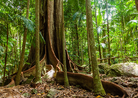
Subtropical
In subtropical rainforests the vegetation is lush. The forest structure is a tall, closed forest, often with multiple canopy layers. It generally occupies sites below 300 m elevation and is found growing on nutrient-rich soils derived from alluvium and basalt and the required rainfall is generally over 1300 mm per year. This rainforest has high species diversity and many plant forms including tall trees, strangler figs, palms, epiphytes, and ferns.
Dry
Dry rainforests are noticeably less lush than subtropical, as they receive lower rainfall amounts. Dry rainforest usually has 2 tree layers, a diverse canopy, small leaves, large woody vines, and thorny or spiny shrubs. Trees such as bottle trees, hoop pine, and Crow’s ash often emerge above the dry rainforest canopy, and some tree species may lose their leaves for part of the year.
-
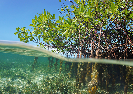
Mangroves are plants adapted to life in shallow, muddy, brackish waters, however the word ‘mangrove’ can also be used to describe the habitat these plants live in. Worldwide there are 69 recognised species of mangrove, with 10 of these known to inhabit the Fraser Coast.
Mangrove forests are diverse communities, found in the intertidal zone of coastal rivers, bays and estuaries. Due to their location, they are frequently subjected to fluctuations in salinity, temperature, nutrients and oxygen availability.
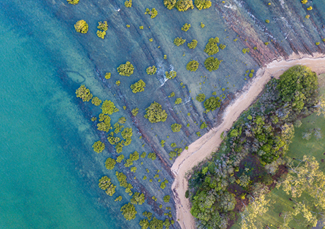
The conditions they tolerate are much harsher than those of other plant species. This makes mangroves unique in their ability to survive in such a dynamic environment. Different species of mangrove have different habitat tolerances. This results in distribution patters known as zonation. Those species which are less tolerant of saline conditions are often found growing higher in the intertidal zone (landward side), or in areas where there is access to significant levels of freshwater.
Species which are more tolerant of saline conditions are found in the lower intertidal areas. These species can also be found in areas where there is minimal tidal influence but increased evaporation from the soil. This creates hypersaline soil, which as times is saltier than seawater.
Mangroves form the interface between marine and terrestrial environments, with animals from both habitats found in these systems. This includes fish, crustaceans, snakes, flying foxes, birds and saltwater crocodiles.
-
Coastal communities are dynamic places. They are forever transforming, thanks to the tides, waves and winds that act upon them. They are also home to a diverse array of specialised plants and animals adapted to living in very harsh conditions.
Beaches form when sediment, usually sand, is transported by waves and deposited in a place where it can accumulate. The sand particles on beaches, however, do not stay in one place. They are constantly in a state of flux thanks to wind and the process of longshore drift. Water particles move up a beach face at an angle with wave direction but return directly down the slope. Sand picked up by the incoming wave is washed up the beach and returned seaward a small distance down the beach in the direction of the waves. Successive waves move sand progressively along the beach, a process known as longshore, or littoral, drift. The path the sand follows is a zigzag pattern. The different zones of beaches are easily identifiable:
Sublittoral (subtidal) – the continental shelf floor that is permanently covered by water.
Littoral (intertidal) – the region between the low tide line and high tide line which is covered with water during only part of each tidal cycle.
Supralittoral (splash) – the region above the high tide line that is covered by water only when large storm waves, high tides or storm surges reach the coast.
-
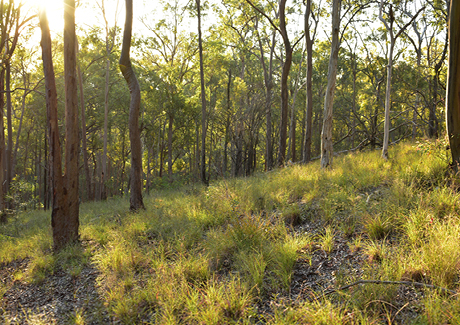
Open forest is a vegetation type with moderately tall trees and a reasonably open canopy to let in light, with a grassy or shrubby ground layer. Forests tend to be named after their dominant canopy trees. For example, in an eucalypt open forest, eucalypts are the most common canopy tree. Many woodlands have eucalypts, wattle, or paperbarks as the dominant trees.
A great amount of wildlife can be found in these habitats. They may include gliders and wallabies, goannas and snakes, and a variety of birdlife. There are also many small and interesting invertebrates such as centipedes, flies, and beetles, that call woodlands home.
Natural hollows are found in woodlands and can take more than 100 years to form. These hollows are essential for a multitude of local species of birds and mammals which depend on them for nesting and shelter.
-
World Wetlands Day is celebrated every year on 2 February - the date of the adoption of the Convention on Wetlands in 1971.
The Fraser Coast has many wetlands that are accessible and easy to explore.
Please remember to leave the area as you found it (or better yet, pick up any litter you find) and enjoy wildlife from a distance without disturbing them. Binoculars are always a great way to view wildlife more closely.
Anembo Lake System
LOCATION: around Ann, Margaret and Truro Streets, Torquay.
This series of lagoons was once a coastal wetland. Although modified, the lakes provide important habitat, especially for waterbirds and help filter urban run-off before it enters the Bay.
Arkarra Lagoons and Wetlands
LOCATION: Corner Panorama Drive and Sempfs Road, Dundowran Beach
Tracks allow you to explore the different lagoons of the wetlands and observe a range of flora and fauna, particularly wetland birds.
Cheelii Lagoon
LOCATION: Ivor Drive, Burrum Heads
This lagoon is named after the near-threatened Melaleuca Cheelii, a species of paperbark which grows naturally here and at a few other locations within our region.
Fay Smith Wetlands
LOCATION: corner Victory and Neptune Streets, Maryborough
Walking tracks, including a boardwalk allow you to wander through this haven for birds and other wildlife
Hervey Bay Botanic Gardens
LOCATION: Elizabeth Street, Urangan.
Several lakes and wetland areas to explore and enjoy. Dayman Street Walkway and the bridge crossing behind Aldi Urangan provide views of the wetlands to the rear of the Gardens.
K’gari
K’gari has many beautiful wetlands throughout the island.
Maaroom, Boonooroo, Tuan, Poona and Tinnanbar
Our coastal townships are the best places to see the Great Sandy Ramsar.
Migratory waders can be seen on mudflats throughout the Strait. Please take extra caution not to disturb shorebirds when visiting these areas as they must feed and rest, in preparation for their return flight to the northern hemisphere to breed.
Insect repellent is advised when visiting these coastal areas.
Pantlins Reserve and Kingfisher Lakes
LOCATION: between Nissen Street and Conservation Drive, Urraween
This wetland area is part of the Eli Creek Catchment and includes remnant vine forest, man-made lakes and remaining paperbark forest areas. Kingfisher lakes Estate was built in the wetland area that was formerly “Nature World” wildlife park.
Pantlin’s Reserve is best accessed from Nissen Street or Spotted Gum Court. Parking space is limited within the Kingfisher Lakes Estate but is possible to park along Fairway Drive or at Eli Waters Shopping Centre and follow the paths which lead to the lake.
River Heads
LOCATION: the walking track between the Boat Ramp and Davidson St (approx. 900m)
This track provides some excellent view points of the Strait as well as the mouths of both Mary and Susan River. The track entrance is located on the Susan River (southern) side of the boaties carpark, at the edge of the rainforest patch. -
Heathlands are usually characterised by dense, low shrubs and ground cover. Along the sandy coast of south-east Queensland and north-east NSW, they are known as Wallum.
This habitat once dominated the coastal plains of SE Queensland, though it has largely been lost to urban development. They are associated with having low nutrient soils and may be either a ‘dry’ or ‘wet’ heathland, with flora similarities shared by both.
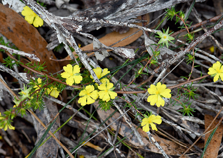
The leaves of heathland plants have a variety of ways to overcome tough environmental conditions. Thick leaves, with high reflective, waxy, or hairy surfaces assist with the amount of direct sunlight the plants receive. High oil content is common to reduce the plant's appeal to animals that may want to eat them.
Heathland plants can grow into a dense cover providing birds and reptiles protection in search of insects and other invertebrates. Many of the plants flower, providing a spectacular wildflower display and attracting a diverse range of insects and other animals. Heathlands are home to some unique creatures that have adapted to live in a challenging physical environment including the wallum frogs. They support more than 80 species of birds and small marsupials such as dunnarts, bandicoots, and potoroos.
Features of heath include:
- Plants that are shorter than two metres.
- Plants that cover at least a third of the ground area.
- Plants that are mostly shrubs and stunted trees like Banksia, Angophora, Lomandra, Hakea, and Xanthorrea.
- Occur where drainage is poor.
- Soils have low levels of nutrients.
Threats to the heathlands include urban development, inappropriate fire management regimes, grazing impacts, and invasive weeds and animals. The Fraser Coast region is the northern limit for the wallum heath habitat.