Rural West
Local Information
-
The Rural West localities of Fraser Coast Regional Council are not immune to natural disasters.
Floods
Although they are not exposed to major riverine flooding they are at risk of localised flooding from the creek systems leading into the broad Mary River and Burrum/Cherwell catchments during severe weather event.
The Munna Creek sub-catchment is the Mary River catchment’s largest sub-catchment with approximately 15% of the total Mary River catchment area.
Important Links
Be Prepared and Get Ready - Flood Information
Latest River Heights for Munna Ck at Teebar
Latest River Heights for Munna Ck at Marodian
Mary River Flood Warning Network Map
Burrum Basin Flood Warning Network
2013 Floods
Taken from the Munna Creek Catchment Waterwatch Network Report 2010 - 2013
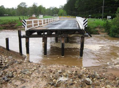
Clifton Bridge near Brooweena
In 2013, like the January 2011 floods, the worst flooding occurred in sub-catchments located downstream of Gympie in the middle reaches around Miva, Tiaro, western section (Wide Bay Creek - Kilkivan, Woolooga & Glastonbury Creek) and north-western sections (Munna Creek - Brooweena, Teebar) of the Mary River Catchment. The highest daily rainfall totals recorded at the peak of the January 2013 rain event (27/1/13) in the Mary River catchment were located in the north-western Munna Creek sub-catchment, with Brooweena (in the upper Munna Creek) recording 336mm and Marodian (in the lower Munna Creek) recording 347mm.
Locals in the Upper Munna Creek catchment near Teebar reported this was one of the largest floods in living memory with floodwaters reported under the Teebar Hall. Calgoa Creek recorded the highest flood level in living history.
-
The recent bushfire seasons experienced in Australia highlight the important contribution that RFS volunteers make not only to the state of Queensland but across the country. RFS volunteers provided duties including firefighting, catering, incident management, logistics support, operational planning, community education, and evacuations.
Brigades across the state work to help prepare for fire seasons by training new members, conducting hazard reduction burns, and educating members of the community to prevent, prepare for, respond to and recover from the impacts of fire and emergency events.
RFSQ volunteer provide services in their local area, including:
- Firefighting landscape fires
- Hazard prevention and mitigation advice
- Issuing permits and fire warden activities
- Community education and engagement
- Disaster management response and recovery options.
For more information and contact details use this link and map to find Brooweena. Fire Wardens at your local Fire Brigade.